Before we get straight into things, I mentioned at the end of the last entry that I'll be discussing an alternate history of the area in the next (this) post. That will now be postponed, and form a later, separate entry - this one has already got a lot of content and sketches for you to digest!
Inspirational locations further afield
For one of the blog entries for Coastguard Creek, I shared a sketch montage of many inspiring (New Forest) locations. As promised at the time, I'm back with more; but this time from locations elsewhere (albeit within 20 miles). Some sketches aren't quite as detailed as others due to being done at different times, but I still think it helps to give a broad sense of what I'm looking to reproduce, in some capacity:

Above: Mudeford Sandbank is a spit forming a narrow entrance that leads into Christchurch harbour, and is on the south side of the channel. Unsurprisingly, the large black building above is called the 'Black House'! The sandbank is famed for its ridulously expensive beach huts - which can be lived in from April to October every year; often with a £250k price tag. The spit used to have sand dunes, but visitor pressures have long since eroded these down to almost nothing. On the other side of the narrow channel is Mudeford Quay, with a ferry service to the sandbank every 15 mins in peak season.

Above: Originally based in Romsey until 1917, Berthon moved to Lymington somewhen after that date. Amazingly, despite being an international business now, the headquarters is still in Lymington today - a surprising feat in this day and age! The sketch above (albeit with artistic compression due to not wanting to draw every single house), shows the yard and surrounding area in 1928. Further expansion (to the left) occured, although in 1942 it was dealt a blow (just like Husband's Shipyard at Cracknore Hard) when a German bombing raid destroyed the sawmill, 2 workshops, and a house. The scene above is typical of many such boatyards found not just in the New Forest, but also in the surrounding area.

Above: Dibles Wharf was located in Southampton, along the western side of the River Itchen. The company (Corralls/PD) had various locomotives at their disposal, including the B4 tank 'Corrall Queen' shown above - which is seen shunting typical 16t mineral wagons. Note that the wagons are shunted in pairs, with the end doors next to each other (as denoted by the white diagonal stripe on the bodyside). This meant they could use the wagon tippler, which allows for two wagons to unload at the same time (although only one is shown above). The coal discharges into a hopper in the middle, below the track. Wouldn't it be great to model this!

Above: Holden's Scrap and Recycling Yard needs no introduction if you've been following the development of Coastguard Creek! Base on photos kindly provided to me by RMweb user 'petethemole', I've drawn the above sketch which shows the compact nature of the yard. Note the winch shed at the end of the slipway, and the rusting barge in front of it! It may not be a photogenic location, but that makes it no less inspirational to me.

Above: Solent Shipyard could be found on the River Hamble, and as you can see, dealt with some pretty large watercraft! The most interesting features here are the multitude of tin sheds, with the signwriting on the roof of one, and the derrick crane in the foreground. The latter seems quite unusual in that the outriggers (or whatever the technical term is!) do not sit on top of tall concrete blocks, but ones that are flush with the top of the quay. The supporting beams thus also sit flush, which is quite unlike any other example I've found so far. As a result, it would be a good one to model as it would not be quite so imposing on a layout!

Above: Langston (spelt without the 'e' for some reason) saw as many as 30 trains a day during summer months, and the level crossing caused absolute havoc with traffic! Fascinatingly, the line was solely the domain of the A1/A1x 'Terriers', the reason for which we'll see later (although I suspect if you're reading this, you already know!). The ground frame/signal box on the left is believed to be the original, although the platform was rebuilt from precast concrete in 1950; replacing the earlier wooden example. Sadly, the stationmaster's house (just visible behind the sign on the right) burned down in a suspected arson attack in 2018, and was subsequently demolished. Nothing else remains of the station, although the route the line once took can be walked.

Above: Bosham Quay may seem like one of the more random locations to feature, but I became quite fascinated by the tidal road, which runs in front of the houses seen in the sketch above. As you can probably tell, there are a fair amount of salt marshes and mudflats, and the hefty brick walls (with their buttresses) help to quite literally hold back the tide! The little building on the far right was of particular interest, although I know nothing more about it.
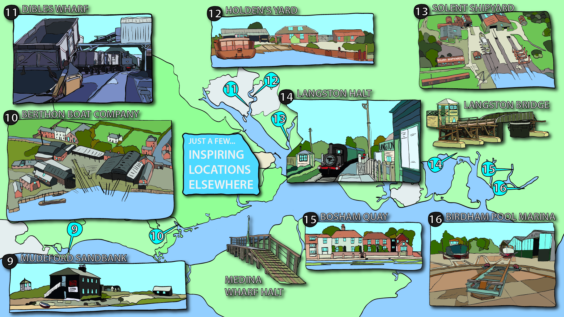
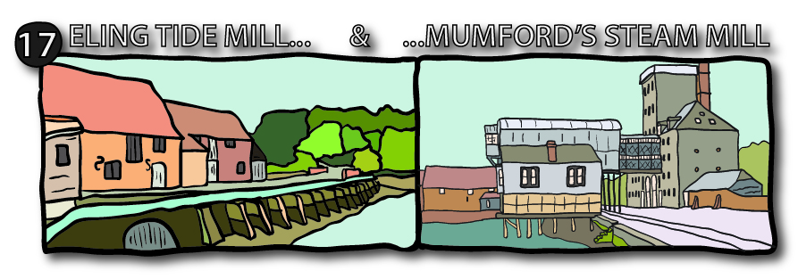
Above: Birdham Pool Marina is nearby, and used to feature this very interesting contraption - sort of akin to a sector plate on a model railway. It was used to move boats straight from the slipway (out of shot to the right) onto the concrete apron so that they could be worked on. I presume there was once a winch on the left, and that the boats were then pushed by hand or tractor into position. Unfortunately, the sector plate has now been removed and infilled, and large tractors now move boats around, which are lifted into the water via a modern boat lift rather than a slipway.
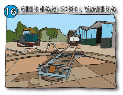
Medina Wharf Halt is obviously another wooden construction, albeit a much... simpler affair! It was found on the Isle of Wight, on the route into Cowes from Newport. Medina Wharf itself opened in 1878 for unloading coal and merchandise, and was served by boat and rail. The halt shown above was private; provided solely for workmen, and thus never appeared in public timetables. I have to say - the simplistic nature of the construction really appeals to me!
Looking at New Forest coastal industries
Last blog entry, I showed how important it is to take a step back and really think about the practical aspects of layout design. Part of that was to do with ensuring that sidings actually serve a purpose...so, with that in mind, I decided to do a bit more digging about any industries that can and could be found along the New Forest coast. To that end, I produced the following timeline showcasing some of the more impactful ones; going from 1700 all the way to the present day...

Whilst some of the more interesting and rarely modelled industries died out before the 50s when my layout will be tentatively set, there is still plenty of opportunity to include some sort of industry.
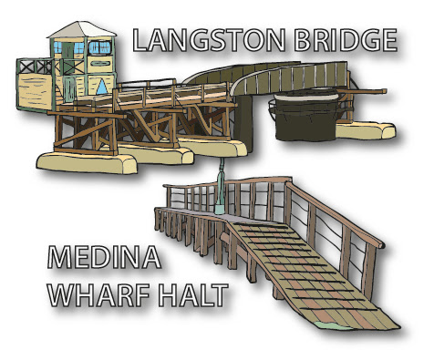
Above: I've grouped these together not just because they were right next to one another (you can see the tide mill in the left background of the right hand sketch), but also because they are both obviously mills of some description. Despite that, they are vastly different in design, clearly!
There's been a tide mill at Eling for over 900 years - the current one dates from the mid 1700s, and replaced the earlier 1420 version. The causeway that forms the mill pond behind has been breached numerous times in its long life, and is still a toll road to this day. The current mill worked right up until 1948, and, after a period of disuse, was thankfully restored in the 70s/80s and turned into a visitor attraction. It's two waterwheels are still extant; one of which is still used to grind wheat into flour - making it one of the last surviving working tide mills in the world producing flour on a regular basis! Quite the accolade. It was again refurbished in 2015, which brings me onto Mumford's Steam Mill...
...this was originally a grain store, but was converted into a steam mill in 1890. It would certainly be an interesting scene to model, however, being a 4 storey building with an additional 3 storey tower on top (not to mention the triple linked silos in front), it would take up a lot of space! The building burnt down in a fire in 1966, leaving just the ruined shell. Thankfully, the lower storey was eventually redeveloped using some of the original materials and turned into a museum and cafe to compliment the tide mill, with brand new apartments above sympathetically designed to look like a mill with sack hoist protrusions. Here's a 1950s view, and perhaps a 20s or 30s view (judging by the fact that the silos are still there, but aren't in the 50s view, and also taking into account similar photos taken around that time).
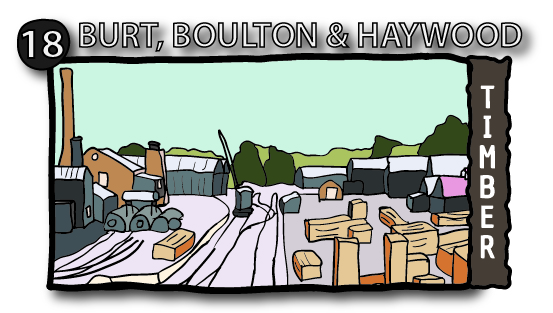
Above: Of particular interest is Eling Wharf, and it's many industries over the years. This was served via a short (1/2 mile) branch from Totton station. Whilst the Burt, Boulton & Haywood timber yard and the South Western Tar Distilleries creosote works were the two main users of the line (certainly from 1923 onwards), the last rail-served industry there was a stone (crushing?) plant which closed around 1993 (see this photo for a stone train in 1988). Whilst there is no longer any rail access, some of the rails within the wharf are still embedded in the concrete, including a section along Eling foreshore, which once connected, via a wagon turntable, the wharf to Mumford's Steam Mill (adjacent to the tide mill).
Anyway, it was the timber works that really took my interest; just take a look at this fabulous photo of Eling Wharf - note the Ruston and self-propelled steam cranes - all of which were used to shunt wagons. A little late (70s) for my period, but I doubt much changed from the 50s... and besides, there's always Rule #1 of model railways (let's be honest; after seeing that photo, how could I not buy my own Ruston?!). The Ruston, arriving in 1966, replaced a trio of steam engines - I believe being; a Black Hawthorn, a Manning Wardle, and lastly an Andrew Barclay. The steam cranes continued to work the wharf throughout. After 1973, the heavier (stone) industry that popped up needed to be worked by more powerful locomotives; so BR mainline engines were used - though the Ruston continued to be used by the timber yard and creosote works. That was, until 1975; when the Ruston was disposed of after cessation of the Tar Distilleries. Here's a photo found on the Eling Tide Mill Experience Facebook page giving an amazing overview of the entire site - phenomenal stuff! As an aside, the second page of this PDF gives some extra info about the ships that called there (although 1:76 scale ships seem to be few and far between, and would be likely to take up too much space to model anyway).

Above: The Husband family moved from London to start a yacht building company here at Cracknore Hard. When WWII arrived, the shipyard was used for the war effort, including for the construction of Mulberrry Harbour components, although a bombing run in 1940 set both building sheds alight, together with the boats within. Other than yacht building, they also serviced oil tankers from Fawley refinery.
The sketch is based from an aerial photos taken in the 1940s, and shows that the shipyard at this time was surrounded by unreclaimed saltmarsh. There were several sheds - the largest of which served two slipways. A long jetty was built alongside, with other slipways and sheds constructed on the south side. A railway spur from the Fawley Branch was built from a junction south of Marchwood Station.
Sadly work dried up, and it closed in 1999 - the buildings were demolished a few years after closure, except one; alongside the shipyard was a pub. Husband’s bought it when it closed in the late 70s, turning it into offices. Today it is used by a sea container company, also as offices, and is now surrounded by stacks of containers! The ends of the two railway sidings are still embedded in the concrete.
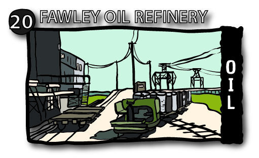
Above: The refinery construction started in 1921. Amazingly, despite the sprawling site, it survived WWII bombing runs unscathed, although refining ceased during the war. Postwar, further expansion occured between 1949-51. Despite previous plans for a railway line to Stone Point, it was the construction of the Fawley Oil Refinery that kickstarted the Fawley branch. There were numerous reception sidings in Fawley, as well as the loading racks. The refinery also had its own extensive narrow gauge railway, as well as an aerial ropeway and jetty to transport drummed asphalt. Sadly, due to new pipelines which are able to transport 70% of all oil, rail traffic dwindled, resulting in the last train leaving Fawley in 2016. The internal narrow gauge line was dismantled long before this, in 1961, although the dual gauge loco shed still remains. Much of the original AGWI refinery has been abandoned in favour of the more modern areas of the site; whilst the jetty visible above still remains, it is no longer used, and the aerial ropeway and asphalt plant are long gone.

Above: The New Forest has a long history of military presence, not least on Calshot Spit. Since the building of Calshot Castle in 1539, right up until the RAF base closed in 1961, the spit has been in military use. When the RAF base opened in 1913, a narrow gauge railway was built from Eaglehurst Camp to the end of the spit, and serviced many of the workshops and hangars - bringing personnel and stores down the line. The railway was abandoned in 1960 after the wagons were found to be in a poor state of repair. The base was predominantly a seaplane/flying boat base, being ideally suited on the sheltered waters of the Solent.
However, it wasn't all about the military - the base was famous for its involvement in the Schneider Cup Races, where seaplanes/flying boats raced at speeds of up to 400mph! The races (1913-31) were set up to promote the development of seaplanes, and their inherent benefits of being able to take off and land on water; thus removing the need for expensive runways. This page tells all.
Sadly nothing remains of the railway, although the church at Eaglehurst Camp is still in use, and several of the large hangars on the spit are used by Hampshire County Council as a huge recreation centre; including a velodrome, climbing wall, and as a home for various watersports. The castle is now a museum, and is run by English Heritage.


At Moses Dock (south of Lymington) two red brick buildings still exist; these are believed to have been the furnaces for one of the many salterns in the area. Most salterns had closed by the 1870s, and indeed, clearly these structures have needed strengthening with a multitude of buttresses and brick ties in order to survive today!
What next?
With so many inspiring locations, it can be hard to narrow down the options! Clearly, however, there are some here that either I have done before (RAF Calshot, Fawley Oil Refinery), or that ended before the period that Coastguard Creek will be set in (salterns, brickworks). Conversely, that is not to say that some of the features cannot be modelled in some fashion, even if disused! A case in point is Bailey's Hard, where the brickworks would make for an interesting scene; especially with the circular 'beehive' kiln and the tall chimney. The sketch drawn earlier is exactly the type of scene that would work really well at the back of a layout (or in front of a fiddle yard).
If all else fails, I suspect I could always convince BRM to let me model one (or some) prototype scenes for future how-to articles... (he says, looking at the literal wall of dioramas already in the studio!)
On a slightly more serious note, something that has really been hammered home by my research is the lasting legacy that military operations of various types have created on the New Forest and surrounding area - especially the D-Day landings in 1944. As the layout will be set between the 40s-60s, this could be an incredibly important and interesting subject to model. I have hinted at this in the past with the remnants of the D-Day remains at Lepe, but I can see a lot of potential modelling the run-up to D-Day, rather than the slowly rotting remains in the decades that followed. Even more fascinating would be to model both; using swappable scenes! That, however, may be a bit far-fetched...
...whatever the case, one thing I'm certainly not short on are inspirational locations! In due course (although I've been saying that for a year or so now) I would like to spend a day or two exploring and photographing some of these places (be it still existing, or otherwise), and really soak in the atmosphere and note the details that could be fun to model. Certainly, a visit to the Eling Tide Mill Experience should prove both interesting and worthwhile; amongst other places.
Bonus: As a complete aside, you may remember last time that I talked about the Bramble Bank in the Solent. Well just in case you're interested, here's some more information about it that you may enjoy - I certainly did!
Comments
Post a Comment